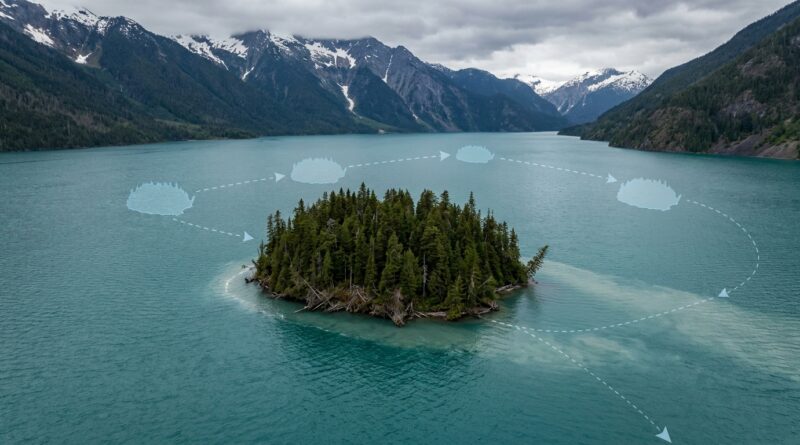
The Island That Slipped Its Moors: How a Forest the Size of a Stadium Broke Free and Sailed Across Canada’s Largest Lake
You are not imagining it. A mysterious floating island Canada reservoir story really did show up in satellite images, and yes, it sounds fake at first. That is part of why people got so hooked. On Williston Lake in northern British Columbia, a chunk of land covered in mature trees appeared to break loose, drift away, then turn up again nearly 20 miles from where it started. If you have ever seen a viral clip and thought, “Come on, that has to be edited,” this is one of those cases where the real answer is stranger than the first rumor. The good news is that this was not magic, and it was not an AI image glitch. It was a rare but very real mix of geology, water levels, root systems, and careful satellite tracking. Once you see how it happened, the whole thing becomes less spooky and much more fascinating.
⚡ In a Hurry? Key Takeaways
- The “phantom island” was most likely a floating peat and soil mass, still carrying a forest, that broke free and drifted across Williston Lake.
- When a wild viral claim pops up, check for repeat satellite images over time instead of trusting one dramatic screenshot.
- This matters because it shows how climate, reservoir engineering, and open-source satellite tools can create and reveal very real anomalies.
What actually happened?
The short version is simple. A fully forested chunk of ground on Williston Lake seems to have detached from the shoreline and floated away.
Not a raft. Not logging debris. An actual island-sized mass with trees on it.
Reports and satellite comparisons suggest this landmass first appeared where no island had been visible before, then disappeared, then later reappeared far away. That is what made the story explode online. It looked like new land had materialized out of nowhere.
But the better explanation is more grounded. Literally. What likely broke loose was a mat of peat, soil, roots, and vegetation thick enough to support mature trees. Once separated from the shore, it could float and travel with water movement and wind.
Why people first thought it was fake
This is where the story gets very modern, very fast. We now live in a world where strange satellite images get dismissed for two opposite reasons.
Some people believe them too quickly. Others assume everything weird is AI-generated.
That second reaction is understandable. A forest the size of a stadium drifting across Canada’s largest lake sounds like clickbait. Officials and observers reportedly had to rule out bad imagery, seasonal differences, and plain old internet nonsense before taking the case seriously.
That is actually the healthy approach. If an image looks impossible, start with boring explanations first. Ask:
- Is this the same season and water level?
- Could clouds, shadows, or image stitching be fooling us?
- Do multiple satellite passes show the same thing?
- Is the feature moving in a way that matches wind or current?
In this case, the fact that the island was documented across more than one pass is what moved it from “probably a hoax” to “something unusual is happening here.”
How can an island float in the first place?
It sounds impossible until you remember that not all “ground” is solid rock. In wetlands and reservoir edges, the land can be more like a thick sponge than a slab of concrete.
Peat can float
Peat is partly decayed plant matter. It is light, fibrous, and often packed with trapped gases and roots. In some places, it forms mats thick enough for shrubs and trees to grow on top. If that mat breaks free, it can float.
Tree roots can hold the whole thing together
A forest is not just trunks sticking out of dirt. Roots knit the soil into a web. That web can help a chunk of land stay intact even after it detaches.
Reservoirs change shorelines
Williston Lake is not a natural lake in the usual sense. It is a huge reservoir shaped by dam operations and changing water levels. Those ups and downs can weaken shorelines, saturate soils, and create the conditions for breakaway masses.
Wind does the towing
Once free, a floating island does not need a motor. Large reservoirs can have enough surface fetch, which is a fancy way of saying open water for wind to push across, to move big objects over time.
Why Williston Lake is the perfect place for this kind of anomaly
Williston Lake in British Columbia is massive. It is often described as the largest lake in the province, though technically it is a reservoir created by the W. A. C. Bennett Dam. Size matters here.
A huge body of water means long shorelines, flooded valleys, changing water levels, and lots of remote edges that few people watch closely. That creates a sweet spot for weird events. Things can happen far from towns, and they may only become obvious when somebody compares old satellite images with new ones.
That is also why this story feels like a legend. If the same thing happened next to a city waterfront, we would have drone footage in an hour. Out here, the first witnesses were pixels from space.
What likely caused the breakaway
No single public explanation covers every detail yet, but the leading factors make sense together.
1. Saturated ground
If the soil mass was already waterlogged, it would have been more buoyant and less tightly anchored than normal land.
2. Erosion at the edges
Wave action and changing reservoir levels can undercut a bank from below. From above, the ground may still look solid.
3. Root-bound surface layer
Trees and vegetation can create a surprisingly tough top layer. That lets a detached section stay together instead of crumbling immediately.
4. Wind and current over time
Once loose, the island could drift gradually, disappear from one viewing angle or image date, then show up again elsewhere.
Why this is more than just a weird nature story
This is the part I think matters most. The story is fun because it is bizarre. It matters because it shows how unstable some landscapes really are.
We tend to think of land as the fixed part and water as the moving part. This flips that assumption. In reservoirs, wetlands, thawing northern ground, and heavily engineered environments, even the “solid” stuff can move.
That has real-world implications for:
- shoreline management
- dam and reservoir monitoring
- wildlife habitat
- boating safety
- mapping accuracy
If a forested chunk of shoreline can detach and travel, that is not just a social media curiosity. It is a reminder that human-made water systems can produce strange side effects we do not always notice right away.
How open-source sleuths helped make sense of it
One reason this case has taken off is that regular people can now check the evidence themselves. You no longer need to work for a space agency to compare imagery.
That is a big shift. Satellite archives, map layers, weather records, and terrain tools let online investigators test a claim instead of only reacting to it.
When you see a future “impossible” image, use this checklist:
- Find the exact location.
- Compare multiple dates, not just one image.
- Look for independent sources, such as different satellite providers or local reporting.
- Check whether seasonal water level changes could explain the difference.
- Be open to weird answers, but make the normal ones fail first.
That last point is the key. Skepticism is useful. Knee-jerk dismissal is not.
Could this happen elsewhere?
Yes, though not always on this scale.
Floating islands have been reported in wetlands, peat bogs, and reservoirs around the world. What makes this case stand out is the size, the forest cover, the distance traveled, and the clean satellite paper trail.
So if you are wondering whether this was a one-off miracle, probably not. Rare, yes. Impossible, no.
What to watch for next
The next phase of this story is almost as interesting as the event itself. Researchers, local observers, and remote-sensing fans will likely keep tracking:
- whether the island keeps drifting
- whether it breaks apart
- if similar shoreline sections nearby look unstable
- how seasonal water changes affect its position
If more detailed imagery becomes available, it may also help confirm the island’s thickness and how much of its structure is peat versus mineral soil.
At a Glance: Comparison
| Feature/Aspect | Details | Verdict |
|---|---|---|
| What it was | Likely a floating mass of peat, soil, roots, and trees detached from the shoreline of Williston Lake. | Strange, but scientifically plausible. |
| Why it looked fake | A new forested “island” appeared in satellite images, then vanished, then turned up far away, which looked like an edited image or AI hoax. | Healthy skepticism was fair at first. |
| What readers should learn | Use repeat imagery, location checks, and real-world context before judging viral anomaly claims. | A good framework for future “impossible” clips. |
Conclusion
This is why the story has legs. It sits in that rare spot where the internet’s first reaction is “No way,” but the evidence keeps saying, “Actually, yes.” A mysterious floating island Canada reservoir mystery sounds like folklore dressed up as a headline. Instead, it appears to be a real event documented by satellite passes and explained by a messy mix of nature and human-shaped landscape. That is exactly why it is worth paying attention to. It gives you the thrill of something uncanny without asking you to switch off your brain. Better yet, it offers a useful habit for the next viral clip that claims the impossible. Stay curious. Check the evidence. And remember that sometimes the weirdest thing online is not fake at all. It is just the planet doing something most of us have never had reason to notice before.